Note
Go to the end to download the full example code.
Reproject IRIS SJI (rolled) to SDO/AIA#
In this example we will show how to reproject a rolled IRIS dataset to SDO/AIA.
The IRIS team at LMSAL provides AIA data cubes which are coaligned to the IRIS FOV for each observation the IRIS data search page.
Therefore this example is more a showcase of functionality.
import matplotlib.pyplot as plt
import numpy as np
import pooch

import astropy.units as u
from astropy.coordinates import SkyCoord
from astropy.time import Time, TimeDelta
from astropy.wcs.utils import wcs_to_celestial_frame

import sunpy.map
from aiapy.calibrate import update_pointing
from aiapy.calibrate.utils import get_pointing_table
from sunpy.net import Fido
from sunpy.net import attrs as a
from sunpy.visualization.drawing import extent

from irispy.io import read_files
from irispy.obsid import ObsID
We start with getting data from the IRIS data archive.
In this case, we will use pooch to keep this example self-contained
but you can download the data manually using your browser as well.
You will need to update the path to the data in the next section if you do that.
sji_filename = pooch.retrieve(
    "http://www.lmsal.com/solarsoft/irisa/data/level2_compressed/2014/09/19/20140919_051712_3860608353/iris_l2_20140919_051712_3860608353_SJI_2832_t000.fits.gz",
    known_hash="7ec0f3d63d97bc7620675c78fb6c670ef5b4249d31ef7818435b629c04b72f60",
)
We will now open the data using a helper function which is designed to read all files from a single observation.
sji_2832 = read_files(sji_filename)
Printing will give us an overview of the file.
print(sji_2832)
# ``.meta`` contains the entire FITS header from the primary HDU.
# Since it is very long, we won't actually print it here.
# print(sji_2832.meta)
SJICube
-------
Observatory:           IRIS
Instrument:            SJI
Bandpass:              2832.0
Obs Date:              2014-09-19T05:17:31.110 -- 2014-09-19T07:13:24.610
Total Frames in Obs:   None
Obs ID:                3860608353
Obs Description:       Large sit-and-stare 0.3x120 1s  C II   Mg II h/k   Mg II w s Deep x
Axis Types:            [('custom:pos.helioprojective.lon', 'custom:pos.helioprojective.lat', 'time', 'custom:CUSTOM', 'custom:CUSTOM', 'custom:CUSTOM', 'custom:CUSTOM', 'custom:CUSTOM', 'custom:CUSTOM', 'custom:CUSTOM', 'custom:CUSTOM', 'custom:CUSTOM'), ('custom:pos.helioprojective.lon', 'custom:pos.helioprojective.lat'), ('custom:pos.helioprojective.lon', 'custom:pos.helioprojective.lat')]
Roll:                  45.0001
Cube dimensions:       (65, 387, 364)
Can’t remember what is OBSID 3860608353? irispy has an utility function that will provide more information.
print(ObsID(sji_2832.meta["OBSID"]))
IRIS OBS ID 3860608353
----------------------
Description:                      Large sit-and-stare 0.3x120 1s
SJI filters:                        C II   Mg II h/k   Mg II w s
SJI field of view:                                       120x120
Exposure time:                                               8.0 s
Binning:                               Spatial x 2, Spectral x 2
FUV binning:                         FUV spectrally rebinned x 4
SJI cadence:                                 SJI cadence default
Compression:                                 Default compression
Linelist:                                       Flare linelist 1
We also have the option of going directly to an individual scan.
sji_cut = sji_2832[45]
print(sji_cut)
SJICube
-------
Observatory:           IRIS
Instrument:            SJI
Bandpass:              2832.0
Obs Date:              2014-09-19T06:39:00.270 -- None
Total Frames in Obs:   None
Obs ID:                3860608353
Obs Description:       Large sit-and-stare 0.3x120 1s  C II   Mg II h/k   Mg II w s Deep x
Axis Types:            [('custom:pos.helioprojective.lon', 'custom:pos.helioprojective.lat'), ('custom:pos.helioprojective.lon', 'custom:pos.helioprojective.lat')]
Roll:                  45.0001
Cube dimensions:       (387, 364)
We need to get the coordinate frame for the IRIS data. While this is stored in the WCS, getting a coordinate frame is a little more involved.
sji_frame = wcs_to_celestial_frame(sji_cut.basic_wcs)
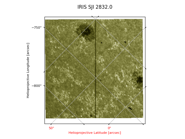
This dataset has a peculiarity: the observation has a 45 degree roll. The image does not have a 45 degree rotation because plotting shows the data in the way they are written in the file. We will a coordinate grid to make this clear. You can also change the axis labels and ticks if you so desire. WCSAxes provides us an API we can use.
plt.figure()
ax = sji_cut.plot()
plt.title(f"IRIS SJI {sji_2832.meta['TWAVE1']}", pad=20)
# You have to specify the grid type to be contours for WCSAxes to plot it correctly.
# This is due to a quirk of how gWCS interacts with WCSAxes.
ax.coords.grid(grid_type="contours")
We will want to align the data to AIA. First we will want to pick a timestamp during the observation.
Lets us now find the SJI observation where the time is closest to 06:00 on 2014-09-19.
(time_sji,) = sji_2832.axis_world_coords("time")
time_target = Time("2014-09-19T06:00:00.0")
time_index = np.abs(time_sji - time_target).argmin()
time_stamp = time_sji[time_index].isot
print(time_index, time_stamp)
23 2014-09-19T05:59:10.020
The fact that it is rolled 45 degrees makes manual alignment tricky and will illustrate the usefulness of working with WCS. We will download an AIA 170 nm image from the VSO. Once we have acquired it, we will need to use aiapy to prep this image.
search_results = Fido.search(
    a.Time(time_stamp, Time(time_stamp) + TimeDelta(1 * u.minute), near=time_stamp),
    a.Instrument.aia,
    a.Wavelength(1700 * u.AA),
)
files = Fido.fetch(search_results, site="NSO")
aia_map = sunpy.map.Map(files[0])
pointing_table = get_pointing_table(
    source="JSOC",
    time_range=(Time(time_stamp) - TimeDelta(5 * 60 * u.minute), Time(time_stamp) + TimeDelta(1 * u.minute)),
)
aia_map = update_pointing(aia_map, pointing_table=pointing_table)
# You don't need to register AIA images unless you need them aligned to other AIA images.
# otherwise you are degrading the data as the affine transform is not perfect.
# But it is the last step to get a level 1.5 image.
/home/docs/checkouts/readthedocs.org/user_builds/irispy/conda/stable/lib/python3.13/site-packages/sphinx_gallery/gen_rst.py:891: AIApyUserWarning: Input map has plate scale [0.612898 0.612898] arcsec / pix which is significantly different than 0.6 arcsec / pix. This function is only meant to be used with maps which have not been resampled or rebinned. The updated pointing is likely incorrect.
  exec(self.code, self.fake_main.__dict__)
Now let’s plot the IRIS field of view on the AIA image.
This IRIS data has no observer coordinate information irispy will set this to be at Earth. This will allow us to transform from IRIS to any another observer.
Using sunpy.map.GenericMap.draw_extent(), drawing regions is straightforward.
aia_bottom_left = SkyCoord(-850 * u.arcsec, -50 * u.arcsec, frame=aia_map.coordinate_frame)
aia_top_right = SkyCoord(-650 * u.arcsec, 150 * u.arcsec, frame=aia_map.coordinate_frame)
aia_sub = aia_map.submap(aia_bottom_left, top_right=aia_top_right)

fig = plt.figure()
ax = plt.subplot(projection=aia_sub)
aia_sub.plot()
extent(ax, sji_cut.basic_wcs)
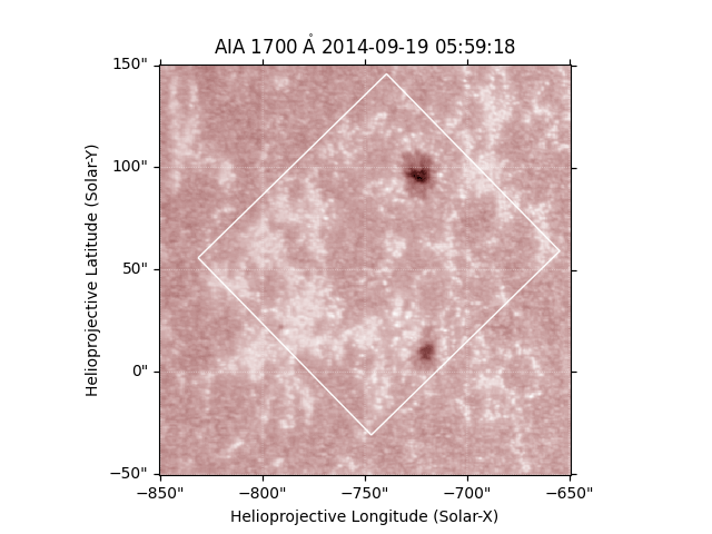
(<matplotlib.patches.Polygon object at 0x71f3dbaee510>, None)
We have a green square showing the region of the IRIS observation. To work with both IRIS and AIA data, it helps if the image axes are aligned, and for this we need to rotate one of them. We can either rotate SDO/AIA to the IRIS frame, or vice-versa.
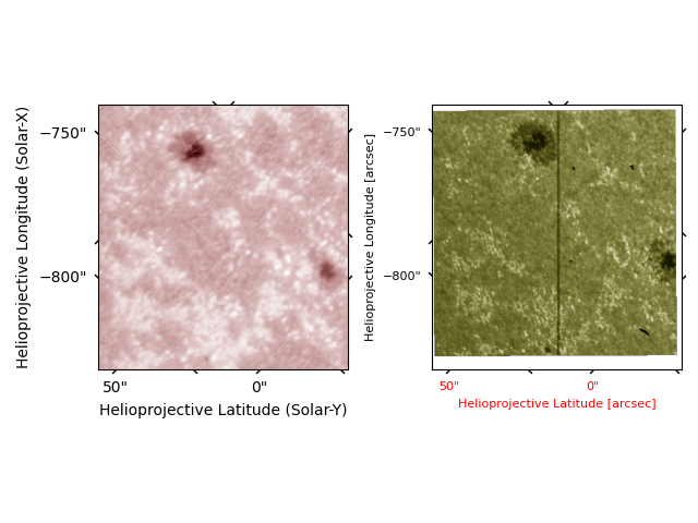
We will rotate the AIA data, using sunpy.map.GenericMap.reproject_to.
As sunpy does not support gWCS (yet), we have to use the basic WCS.
aia_reprojected = aia_sub.reproject_to(sji_cut.basic_wcs)
/home/docs/checkouts/readthedocs.org/user_builds/irispy/conda/stable/lib/python3.13/site-packages/sunpy/map/mapbase.py:3156: SunpyUserWarning: rsun mismatch detected: AIA 1700.0 Angstrom 2014-09-19 05:59:18.rsun_meters=696000000.0 m;  2014-09-19 06:39:00.rsun_meters=695700000.0 m. This might cause unexpected results during reprojection.
  warn_user("rsun mismatch detected: "
Now we can see the results.
fig = plt.figure()
ax1 = fig.add_subplot(1, 2, 1, projection=aia_reprojected.wcs)
aia_reprojected.plot(axes=ax1)
ax1.set_title("")

ax2 = fig.add_subplot(1, 2, 2, projection=sji_cut.basic_wcs)
sji_cut.plot(axes=ax2)

fig.tight_layout()
Finally, one way to visualize the alignment is to plot the AIA contours on the IRIS SJI image.
fig = plt.figure()

ax1 = fig.add_subplot(111, projection=sji_cut.wcs)
sji_cut.plot(axes=ax1)
aia_reprojected.draw_contours(levels=[500], colors=["red"], linewidths=2)
ax1.set_title("IRIS SJI with AIA contours")

plt.show()
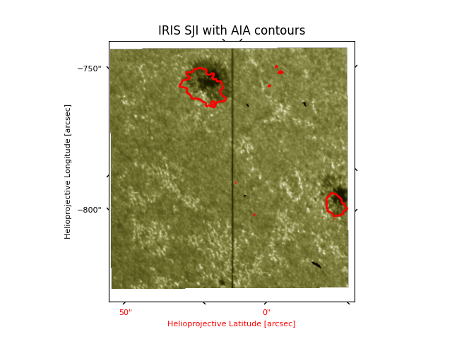
As one can see, the reprojection has not aligned the two images. Since the WCS information was not 100% accurate to begin with, this means that reprojecting alone is not sufficient to get a perfect alignment.
If you want to align, you can check out the following Co-align IRIS SJI to SDO/AIA
Total running time of the script: (0 minutes 13.485 seconds)