Note
Go to the end to download the full example code.
Co-align IRIS SJI to SDO/AIA#
In this example we will show how to co-align a rolled IRIS dataset to SDO/AIA.
The IRIS instrument team at LMSAL provides AIA data cubes which are coaligned to the IRIS FOV for each observation the IRIS data search page.
Therefore this example is more a showcase of functionality.
import matplotlib.pyplot as plt
import numpy as np
import pooch
from sunkit_image.coalignment import coalign_map

import astropy.units as u
from astropy.coordinates import SkyCoord
from astropy.time import Time, TimeDelta

import sunpy.map
from aiapy.calibrate import update_pointing
from aiapy.calibrate.utils import get_pointing_table
from sunpy.net import Fido
from sunpy.net import attrs as a

from irispy.io import read_files
We start with getting data from the IRIS data archive.
In this case, we will use pooch to keep this example self-contained
but you can download the data manually using your browser as well.
You will need to update the path to the data in the next section if you do that.
sji_filename = pooch.retrieve(
    "https://www.lmsal.com/solarsoft/irisa/data/level2_compressed/2025/07/10/20250710_121126_3893010094/iris_l2_20250710_121126_3893010094_SJI_2832_t000_deconvolved.fits.gz",
    known_hash="0875acc65711969a93ce67474b6236bc98ce5a2bc49901ccad0f70ccf1478033",
)
We will now open the data using a helper function which is designed to read all files from a single observation.
sji_2832 = read_files(sji_filename)
We will want to align the data to AIA. First we will want to pick a timestamp during the observation.
(time_sji,) = sji_2832.axis_world_coords("time")
# We need to get a sunpy map as the coalignment works on sunpy maps only for now.
sji_map = sji_2832.to_maps(8)
We will download the closest AIA 170 nm image from the Virtual Solar Observatory (VSO).
Once we have acquired it, we will need to use aiapy to “prep” this image.
search_results = Fido.search(
a.Time(time_sji[0], Time(time_sji[0]) + TimeDelta(1 * u.minute), near=time_sji[0]),
a.Instrument.aia,
a.Wavelength(1700 * u.AA),
)
files = Fido.fetch(search_results, site="NSO")
aia_map = sunpy.map.Map(files[0])
pointing_table = get_pointing_table(
source="JSOC",
time_range=(Time(time_sji[0]) - TimeDelta(5 * 60 * u.minute), Time(time_sji[0]) + TimeDelta(1 * u.minute)),
)
aia_map = update_pointing(aia_map, pointing_table=pointing_table)
# Crop the AIA FOV to be similar to IRIS but larger to ensure full coverage.
# It needs to be at least as large as an expected shift, otherwise you will contend with edge effects
aia_crop = aia_map.submap(
bottom_left=SkyCoord(
sji_map.bottom_left_coord.Tx - 50 * u.arcsec,
sji_map.bottom_left_coord.Ty - 50 * u.arcsec,
frame="helioprojective",
observer=sji_map.bottom_left_coord.observer,
),
top_right=SkyCoord(
sji_map.top_right_coord.Tx + 50 * u.arcsec,
sji_map.top_right_coord.Ty + 50 * u.arcsec,
frame="helioprojective",
observer=sji_map.top_right_coord.observer,
),
)
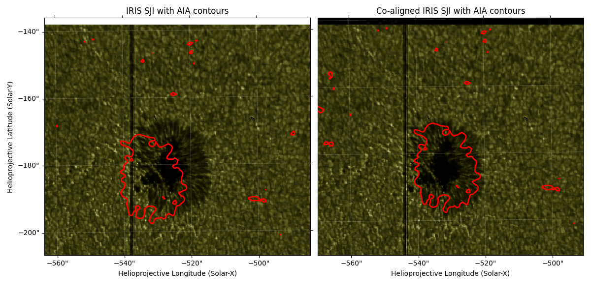
# ###############################################################################
# One way to visualize the alignment is to plot the AIA contours on the IRIS SJI image.
#
# As one will see, the alignment is not perfect. Creating a pixel perfect WCS
# is very difficult due to uncertainties in locations and the pointing information.
#
# So what we can do is a cross-correlation between IRIS and SDO/AIA to see if we can
# improve this. The following uses ``sunkit-image`` and currently only works on sunpy Maps,
# so we will use the SJI Map for this case and not the cube.
#
# Before co-aligning the images, we have to make sure that both images have the
# image scale, as this is important for the routine.
#
# Now we can co-align cross-correlation using the "match_template" method.
# For details of the implementation refer to the documentation of
# `~sunkit_image.coalignment.match_template.match_template_coalign`.
# Before co-aligning the images, we first resample the AIA image to the same plate
# scale as the IRIS image. This will ensure better results from our coalignment.
nx = (aia_crop.scale.axis1 * aia_crop.dimensions.x) / sji_map.scale.axis1.to(u.arcsec / u.pix)
ny = (aia_crop.scale.axis2 * aia_crop.dimensions.y) / sji_map.scale.axis2.to(u.arcsec / u.pix)
aia_upsampled = aia_crop.resample(u.Quantity([nx, ny]))
# We need to prepare the SJI data by removing NaNs.
sji_map_corrected_data = sji_map.data.copy()
nan_mask = ~np.isfinite(sji_map_corrected_data)
if np.any(nan_mask):
sji_map_corrected_data[nan_mask] = 0
sji_map_corrected = sunpy.map.Map(sji_map_corrected_data, sji_map.meta)
coaligned_sji_map = coalign_map(sji_map_corrected, aia_upsampled, method="match_template")
# ###############################################################################
# Finally, we can plot the results of the co-alignment.
fig = plt.figure(figsize=(12, 6))
ax1 = fig.add_subplot(121, projection=sji_map.wcs)
sji_map.plot(axes=ax1)
aia_upsampled.draw_contours(axes=ax1, levels=[500] * u.DN, colors=["red"], linewidths=2)
ax1.set_title("IRIS SJI with AIA contours")
ax2 = fig.add_subplot(122, projection=coaligned_sji_map.wcs, sharex=ax1, sharey=ax1)
coaligned_sji_map.plot(axes=ax2)
aia_upsampled.draw_contours(axes=ax2, levels=[500] * u.DN, colors=["red"], linewidths=2)
ax2.set_title("Co-aligned IRIS SJI with AIA contours")
ax2.coords[1].set_ticks_visible(False)
ax2.coords[1].set_ticklabel_visible(False)
xlims_world = [-570, -490] * u.arcsec
ylims_world = [-210, -140] * u.arcsec
world_coords = SkyCoord(Tx=xlims_world, Ty=ylims_world, frame=coaligned_sji_map.coordinate_frame)
pixel_coords_x, pixel_coords_y = coaligned_sji_map.wcs.world_to_pixel(world_coords)
ax2.set_xlim(pixel_coords_x)
ax2.set_ylim(pixel_coords_y)
fig.tight_layout()
plt.show()
/home/docs/checkouts/readthedocs.org/user_builds/irispy/conda/stable/lib/python3.13/site-packages/sphinx_gallery/gen_rst.py:891: AIApyUserWarning: Input map has plate scale [0.612898 0.612898] arcsec / pix which is significantly different than 0.6 arcsec / pix. This function is only meant to be used with maps which have not been resampled or rebinned. The updated pointing is likely incorrect.
  exec(self.code, self.fake_main.__dict__)
Total running time of the script: (0 minutes 24.716 seconds)